Designed around 1284 and built for the most part between 1299 and 1331, Florence's last circle of city walls stretched for about 8,5 kilometres, turning Florence into one of the largest European cities of the time. At first adapted to the new defence requirements, the city wall system gradually lost its military importance, retaining until more recent centuries the function of administratively and fiscally distinguishing the city from its contado. Urban interventions in the second half of the 19th century were aimed at giving Florence an international character on the occasion of the city's proclamation as the new capital of the Reign of Italy in December 1864. To connect the new with the old urban fabric, the entire city wall north of the Arno was demolished and wide boulevards were built in its place, interrupted by squares at the major city gates, the only elements safeguarded.
The isolation of the gates, deprived of their function, has led to them being perceived today as ancient urban furnishings aimed at managing the heavy traffic of the boulevards. The demolition of the walls has led to the loss of Florence's identity as a fortified city and in many, among the citizens themselves, there is a lack of awareness of the social value of the defensive structure, of its role in defining the form and identity of the city, but also that of its own existence.
The reconnection between people and heritage is at the core of Firenze Forma Continua, a project that embraces the principles of the 2005 Faro Convention which promotes the right of citizens, and the entire community, to know and enjoy their cultural heritage defined as "the group of resources inherited from the past which that people identify [...] as a reflection and expression of their constantly evolving values, beliefs, knowledge and traditions. It includes all aspects of the environment resulting from the interaction between people and places through time."
The project stemmed from one of the recommendations of the Joint UNESCO/ICOMOS 2017 Advisory Mission in Florence. The initiative, developed by the Florence World Heritage and relations with UNESCO Office of the Municipality of Florence, in collaboration with HeRe_Lab and the Department of Architecture of the University of Florence, aims at promoting the knowledge on the development of the city and its Outstanding Universal Value, expressed through the physical and social fabric, referring in particular to the phases of expansion of the city identified by the alternation of the walled perimeters.
But in those days the city walls had not been demolished and they must have modified the tramontana, the fierce north wind, for Florence was favoured as a winter resort, especially by retired Anglo-Indian officers and civil servants. Yet it can be the hottest of Italian cities and the coldest.
Sir Harold Acton1
The demolition of the city walls in the 19th century led to the loss of Florence's identity as a walled city. Many, including its own citizens, are unaware of the social value of the defensive structure, its role in shaping the city's form and identity, and even its very existence.
The Firenze Forma Continua project is part of Macro Area 2 "Planning, Conservation, and Knowledge of Heritage" in the 2022 Management Plan for the Historic Centre of Florence2. The main goal of the project is to share the history of the city of Florence and its surrounding territory, linking them to the broader cultural heritage enhancement system. It seeks to revive the city's identity and historical elements through the physical and social fabric, emphasizing the value of cultural heritage through identification, study, interpretation, protection, and conservation.
The project, starting from a detailed analysis of the historical processes that have characterized Florence, promotes the reconnection between people and heritage, drawing on the principles enshrined in the 2005 Faro Convention3. This convention promotes the right of citizens and the entire community to understand and appreciate their cultural heritage, defined as "the group of resources inherited from the past which people identify [...] as a reflection and expression of their constantly evolving values, beliefs, knowledge, and traditions. It includes all aspects of the environment resulting from the interaction between people and places through time" (Council of Europe 2005, Article No. 2.a)4. Specifically, the signatories are called upon to "highlight the value of cultural heritage through its identification, study, interpretation, protection, conservation, and presentation" (Council of Europe 2005, Article No. 5.b)5.
To achieve these, engaging citizens, city users, students, and visitors is crucial to create, or re-create, meaningful "heritage communities". Collaborative seminars with the University of Florence, including courses, seminars, workshops, and labs, actively involve young individuals in building a receptive and enthusiastic community to promote heritage values6.
Firenze Forma Continua project originated from one of the recommendations of the Joint UNESCO/ICOMOS 2017 Advisory Mission in Florence7. Developed by the Florence World Heritage and relations with UNESCO Office of the Municipality of Florence in collaboration with Heritage and Research Laboratory - HeRe Lab - a joint research unit set by the Department of Architecture of the University of Florence, the project aims to promote understanding of the city's development and its Outstanding Universal Value. This value is expressed through both the physical and social fabric, with a particular focus on the city's expansion phases marked by changes in its walled perimeters.
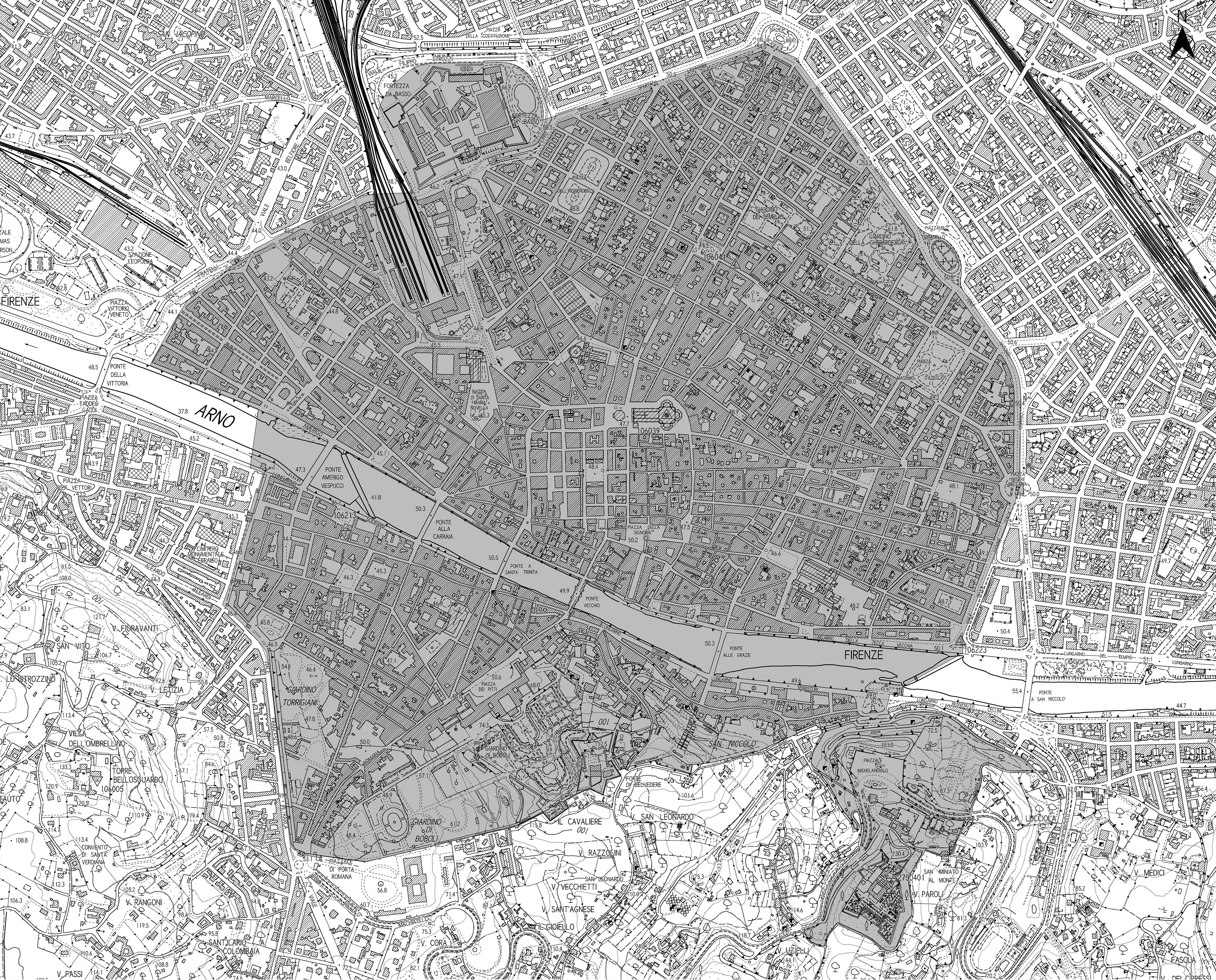
Defining the perimeter of a city and its historic centre is an acknowledgement of its boundaries, spaces, and, consequently, its value. In the processes of enhancing places and themes related to urban identity, promoting a correct interpretation of the city's form can spark the curiosity and attention of both those who are visiting (tourists) and those who reside there (citizens and city users). These elements can contribute to a genuine awareness of the place's value. In the case of the Historic Centre of Florence, a UNESCO World Heritage Site, the definition of a perimeter is particularly important for the preservation of the site itself and its Outstanding Universal Value. This value is traditionally associated with the Core Zone8, typically identified as the area enclosed within the ancient circle of the 14th-century city walls, which constitute one of the specific Attributes of the condition of Integrity of the Historic Centre of Florence site (fig. 2)9.
Territories are historical constructs; they do not exclusively derive from natural development processes but originate from the dual evolution, over very long periods, of settled communities and the environment. They result from centuries of transformations resulting from human behavior and natural evolutionary logic, generated by a continuous process of mutual exchange and refinement between nature and artifice, between spontaneity and planning10.
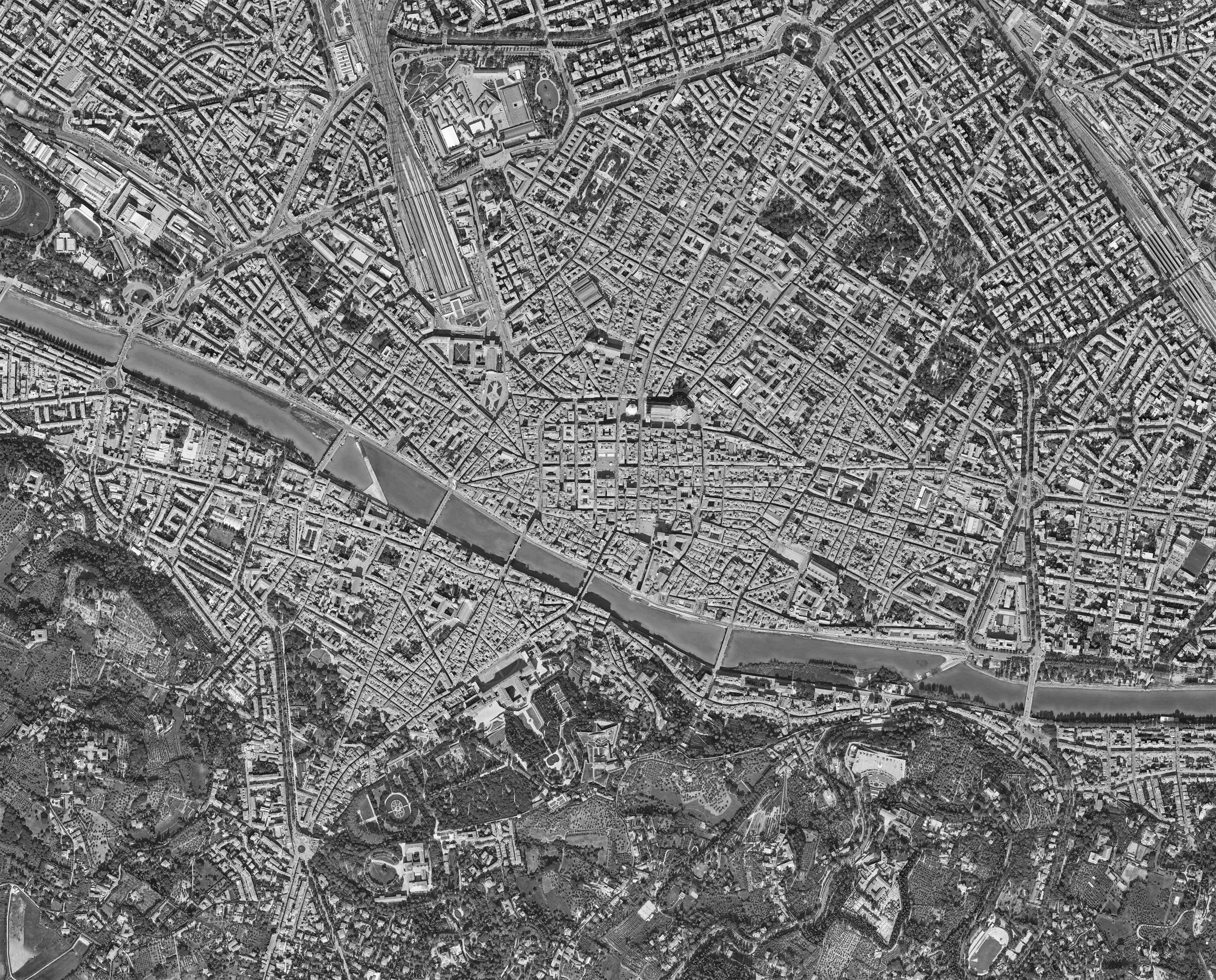
The urban fabric of the city of Florence is the result of the succession of city walls that, from its origin to the present day, have defined - and to some extent continue to define - its boundaries (fig. 3).
The phases of the city's expansion are still recognizable in the urban layout, starting from the so-called Roman quadrilateral, where the imprint of the orthogonal grid of ancient streets reflects the extent of the colony11, protected by brick walls interspersed with four cardinal gates12. Over the next millennium, Florence's fortunes fluctuated, leading to periods of contraction and subsequent expansion into new neighborhoods along major roads13.
It wasn't until the 12th century, around the 1170s, that Florence acquired a new set of walls that would shape the city's urban design for centuries. The first communal wall, built from about 1172 to 117514, rotated about 45° compared to the Roman one to encompass the emerging suburbs. The city's economic and political growth in the late 13th century led to rapid demographic expansion, pushing urban development beyond these new walls.
This expansion marked a clear distinction between the ancient city, characterized by a dense and chaotic fabric enclosed within the late antique walls, and the growing city outside, organized around open spaces hosting new religious centres. The outer cityscape witnessed architectural changes influenced by distinct aesthetic aspirations, reflecting a newfound preference for regularity and rationality.
The construction and destruction of imposed boundaries, which act as limits to the city's growth, are natural processes. They allow the city to continue developing in a loosely disciplined manner, as was necessary for a city like Florence. However, the destruction of the physical perimeter entails the complete loss of awareness of its past existence, even though clear traces of it are preserved in the city's form, the width of its streets, and the arrangement and height of its buildings.
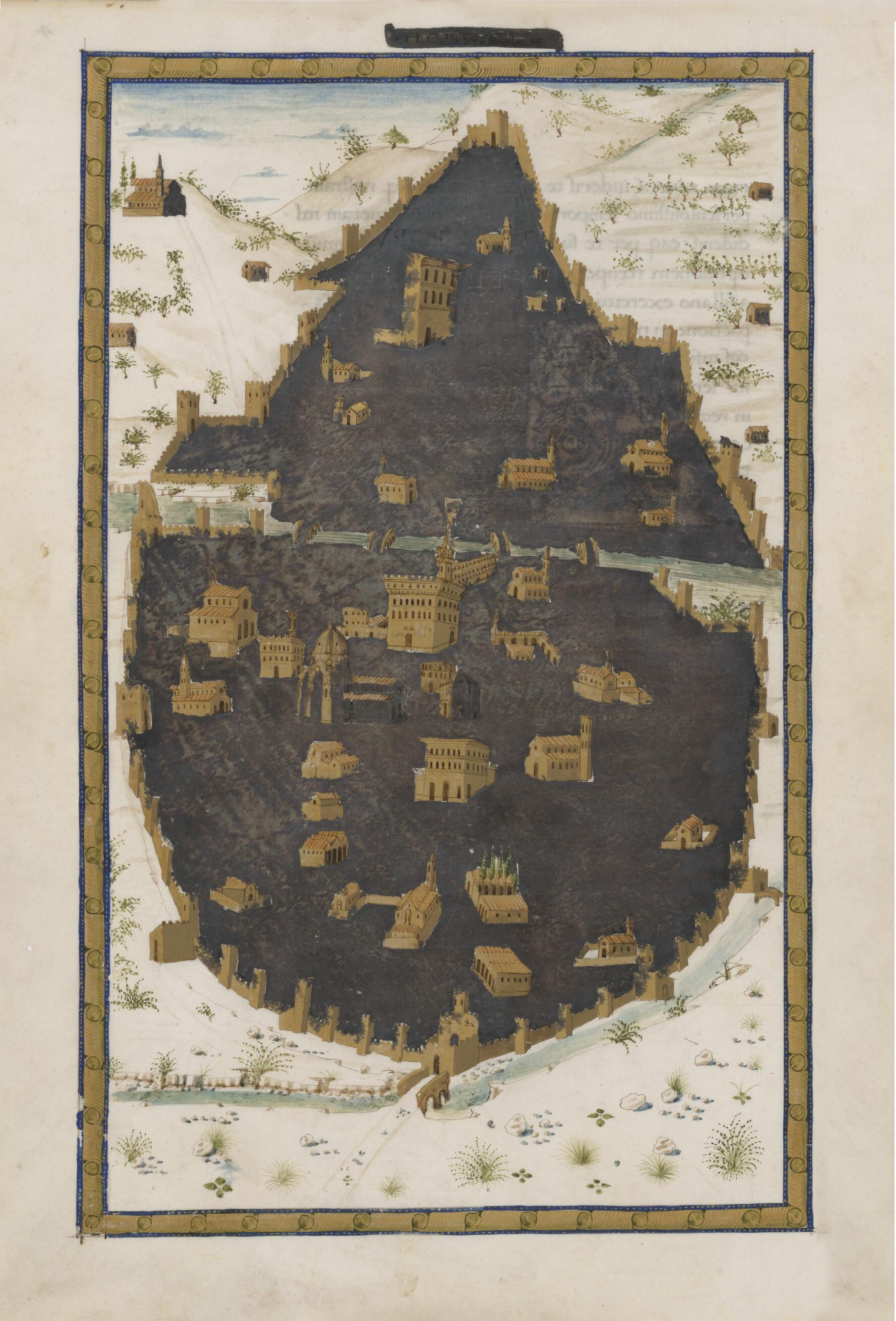
Designed around 1284 and built between 1299 and 1331, the last city wall of Florence stretched for about 8.5 km, encompassing an inner area five times larger than the previous one. This made Florence one of the largest European cities of the time15. The wall was designed with future expansions in mind, incorporating a broad swath of land surrounding the old city core. However, repeated crises throughout the century, notably the 1348 plague epidemic, slowed economic activities and urban expansion. As a result, these green areas would largely remain untouched until the mid-19th century.
Initially adapted for new defence needs, the 14th-century city wall gradually lost its military significance, retaining its role in administrative and fiscal matters, distinguishing the city from its surrounding territory for many centuries16.
Urban development efforts in the second half of the 19th century aimed to give Florence an international character, following the city’s proclamation as the new capital of the Kingdom of Italy in December 1864. To connect the old and new urban fabric, planned immediately beyond the city walls, it was decided to demolish the entire city wall north of the Arno River and replace it with wide tree-lined boulevards, interrupted by squares at major gates — the only elements to be preserved. The destruction of this section of the wall, covering about 4.5 km, served the city's development, as had occurred in the past. Meanwhile, the section south of the river was preserved because the topography of the Oltrarno area would have made any further extensive urban development impractical, especially in an area adjacent to hilly terrain17.
This contrast between what has been lost and what has been preserved illustrates how the loss of identity is not solely tied to the presence of the physical element but also to the destruction of its historical memory. Repurposing for improper functions or a complete lack of function, apart from being a hollow symbol of itself, results in the loss of recognizability even where the element still exists.
The character [of a place] is determined by how things are, and gives our investigation a basis in the concrete phenomena of our everyday life-world18. Only in this way we may fully grasp the Genius Loci; the “spirit of place” which the ancients recognized as that “opposite” man has to come to terms with, to be able to dwell19.
Reflecting on losses and elements that once existed but have since undergone material destruction, ceasing to exist, places the field of design in a pivotal role for recognizing and conveying the history and identity of that place and the people linked to it.
Conscious management of cultural heritage implies the involvement of every individual and the entire community. Ascribing value to cultural resources, preserving them, and passing them on to future generations are responsibilities shared by both state institutions and civil society.
Identity elements often possess enduring characteristics, occasionally changing, and sometimes even forgotten. Nevertheless, a place's essence encapsulates the narrative of its transformations, intertwining in a sort of urban scenography. This system comprises progressive constructions and/or demolitions that shape the ways of life in these locales, altering hierarchies of values, uses and pathways, occasionally hinting at new aesthetic values20.
Contemplating the elements that have been lost encourages an approach to reinterpret places that increasingly focuses on preserving and promoting intangible and cultural values, elevating vacant spaces, and reclaiming historical memory.
An essential element in conveying the concept of a territory in its role as a place is identity, a nuanced and multifaceted notion that requires exploration, given its broad scope21. The identity of a place hinges on three variables: the topographic site, the natural setting; the people who inhabit it; and, lastly, the built environment, the artificial realm. In this sense, communicating the identity of a territory means managing the aesthetics of relationships between different layered contents, sometimes not immediately discernible. Identity resides in relationships rather than in form, and can be described as the enduring unity of the subject amid changing elements - what persists as forms change22.
It is necessary to adopt an approach that considers not only the concept of urbs (the city) but also, and more importantly, that of civitas (the community). On one side, there is the intricate urban setting - the space where buildings stand - urbs - and, on the other side there are the people, a blend of residents and city users - civitas - along with their spaces for interaction, social life, experiences, and collective identity. When an element is lost, a void emerges, sending a clear signal not only within the urbs - through changes and developments in the urban context - but also profoundly impacting the civitas.
In today's context, especially within the context considered in this article23, it's crucial to take into account a diverse spectrum of users - civitas - encompassing citizens, city users, and tourists. Therefore, when dealing with a destroyed, lost, or forgotten element, a dual effort becomes even more pivotal: firstly, bringing it back into memory, and secondly, accentuating its historical significance.
The relationship between identity elements also introduces the phenomenon of belonging. In Christian Norberg-Schulz's essay, Genius Loci: Toward a Phenomenology of Architecture24, a phenomenological approach, characteristic of modern architecture, is employed. Through this approach, it becomes possible to define territorial identity's essence with the term "genius loci." Through this term, one identifies the characteristics unique to an environment interconnected with humans, the habits through which it is lived, and the collective memory of individuals who experience it. It is a layering of data, events, traits, and relationships that emerge with different hierarchies but are always coexistent. Consequently, the territory possesses its own history and characteristics – encompassing the natural, cultural, and technological dimensions. Sometimes, these features are so captivating25 and renowned that they become an intrinsic part of the place's identity, naturally transmitted and embraced, shaping the perceived essence of that particular location. Thus, the identity imagery comprises elements stemming from the aesthetic appreciation of a territory – including knowledge, visions, impressions, values, and associated stereotypes26.
The values-driven approach is particularly suited to the preservation and management of World Heritage sites. It goes beyond mere structures, considering a broader set of values. These values are dynamic, shaped by the participating social groups, and can evolve over time, aligning with changes in social, cultural, environmental, and usage perspectives27.
Nullus locus sine Genio28.
By highlighting and promoting cultural and urban layers on various thematic levels, the project offers a fresh perspective on neglected aspects of history, still identifiable in the urban fabric both as urban gaps and their evolutionary trajectories. Understanding and embracing one's identity means rediscovering imaginaries, popular traditions, symbolic settings, and identity markers. It involves interpreting the city as a scenic backdrop for the community to reconnect with its cultural values. Consequently, students and researchers focus on designing and implementing temporary installations in areas pertinent to the project's vision, typically undervalued or underused spaces. These installations provide information and encourage visitors to pause and appreciate elements, spaces, and views that contribute to the Outstanding Universal Value of the Historic Centre of Florence site.
The project's lab phase began in 2022, starting with a case study on the remaining Oltrarno walls, specifically the section between Porta San Giorgio by the Belvedere Fort and Porta San Miniato, which leads to the Basilica of San Miniato al Monte. This section of the city walls is nestled in the greenery of the steep hill south of Florence and is, therefore, underutilized and relatively unknown. In 2023, attention shifted to the more vulnerable northern area, where most of the city walls have been demolished. Here, the gates, no longer serving their original purpose, are now seen as historical urban features designed to manage boulevard traffic. The removal of the walls has erased Florence's identity as a fortified city, with many, including its residents, unaware of the defensive structure's social value, its role in shaping the city, and even its own existence.
To fill this information gap and promote understanding of the defensive structure's social value and its impact on the city's form, the Firenze Forma Continua portal (www.firenzeformacontinua.it) was created. This informative platform, based on scientific research, targets a broad audience and provides a gradual approach to the topic. The portal narrates the city's history, breaking it down into key developmental phases. Each phase includes a concise description and a synoptic territorial plan, aiding in understanding the urban layout, its relationship with waterways, green areas, and outer neighborhoods. It spans the city's transformations, from Etruscan settlements to the Roman circle, 16th century fortifications, 19th century demolitions, mid-20th century urban plans, and the current metropolitan city. The portal's structure enables ongoing exploration, serving as a resource for future research29.
notes
Acton, Sir Harold. 1982. "A Phantom Botticelli". In The Soul’s Gymnasium. Bury St Edmunds: St. Edmundsbury Press.
In 2022, the third update of the Management Plan for the Historic Centre of Florence UNESCO World Heritage site was released (approved by the Municipal Council on December 30, 2021, resolution No. 670). Florence World Heritage Office and Relations with UNESCO, curated by Francini, Carlo. 2016. The Management Plan for the Historic Centre of Florence - UNESCO World Heritage Site.
On 23 September 2020, with the ratification of the Council of Europe Framework Convention on the Value of Cultural Heritage for Society, better known as the Faro Convention (2005), Italy accepted the principles that enhance the rights of both citizens and the wider communities to better understand and benefit from their cultural heritage.
Council of Europe. 2005. Council of Europe Framework Convention on the Value of Cultural Heritage for Society, Faro October 27, n. 199, Article No. 2.a.
Ivi, Article No. 5.b.
Francini, Carlo, and Gaia Vannucci. 2022. “Firenze Forma Continua: raccontare l’evoluzione della città e del territorio”. In 1972/2022 il Patrimonio Mondiale alla prova del tempo, atti del Convegno Internazionale: 406-411. Florence: Firenze University Press.
UNESCO, and ICOMOS. 2017. “Joint UNESCO World Heritage Centre/ICOMOS Advisory Mission to the World Heritage site of the Historic Centre of Florence”. Florence.
The Core Zone is the area of a World Heritage site, defined during its listing and formally recognized by the World Heritage Centre as an area of Outstanding Universal Value. The Core Zone of the Historic Centre of Florence, inscribed on the World Heritage List since 1982 and expanded through a Minor Boundary Modification in 2021 (44th session of the World Heritage Committee in Fuzhou, China, Decision: 44 COM 8B.56), covers an area of 532 hectares.
For more information on the Criteria and Conditions for which the Historic Centre of Florence is a UNESCO World Heritage Site, see: https://www.firenzepatrimoniomondiale.it/en/home-english/.
Piccinno, Giovanna. 2003. Space Design. Milano: Politecnica.
Via dei Cerretani on the north side, Via del Proconsolo on the east side, Via Vacchereccia to the south side and Via Tornabuoni to the west side follow the line of the Roman defensive circle. Scampoli, Emiliano. 2010. Florence, archaeology of a city (1st century B.C. - 13th century A.D.). Firenze: Florence University Press.
The Roman city wall was likely constructed between 30 and 15 B.C., some time after the colony's foundation, traditionally dated to 59 B.C.
1996. Alle origini di Firenze. Dalla preistoria alla città romana. Exhibition catalogue Museo Firenze Com'era (25 June 1996-19 January 1997). Firenze: Polistampa.
Pagni, Mario, ed. 2010. Atlante archeologico di Firenze. Indagine storico-archeologica dalla preistoria all’alto medioevo. Firenze: Polistampa.
Scampoli, Emiliano. 2010. Op. cit.
Salvini, Monica, and Sara Faralli. 2020. “Archeologia invisibile” a Firenze. Storia degli scavi e delle scoperte tra San Lorenzo, Santa Maria Novella e Fortezza da Basso. Firenze: Edizioni dell’Assemblea.
Fanelli, Giovanni. 1973. Firenze architettura e città. Firenze: Mandragora.
Faini, Enrico. 2010. Firenze nell’età romanica (1000-1211). L’espansione urbana, lo sviluppo istituzionale, il rapporto con il territorio. Firenze: Olschki.
Guidoni, Enrico. 2002. Atlante storico delle città Italiane. Firenze nei secoli XIII e XIV. Roma: Bonsignori.
Spilner, Paula. 1987. “Ut civitas amplietur”: Studies in Florentine Urban Development, 1282-1400. PhD diss., New York University.
Sznura, Franek. 1975. L’espansione urbana di Firenze nel Dugento. Firenze: La Nuova Italia.
Rinaldi, Alessandro. 2007. Sul limitare della città. Decadenza e conversione delle mura urbane a Firenze dal secolo XVII al secolo XIX. Firenze: Edifir.
Poggi, Giuseppe. 1882. Sui lavori per l’ingrandimento di Firenze. Firenze: Tipografia di Barbèra.
Cresti, Carlo. 1995. Firenze, capitale mancata. Architettura e città dal piano Poggi a oggi. Milano: Electa.
Maccabruni, Loredana, and Pietro Marchi, eds. 2015. Una capitale e il suo architetto. Eventi politici e sociali, urbanistici e architettonici. Exibition catalogue Firenze e l’opera di Giuseppe Poggi (Florence, Archivio di Stato, 3 february-6 june 2015). Firenze: Polistampa.
Marchi, Pietro, and Laura Lucchesi. 2018. Una capitale europea: società, cultura, urbanistica nella Firenze post-unitaria. Acts of the Study Days for the 150th Anniversary of Florence Capital (Florence, Archivio di Stato, February-May 2015). Firenze: Consiglio Regionale della Toscana.
AA. VV. 2020. Graphics for the city. Atti del convegno Grafica e segnaletica in un centro storico 1969/2019. Mantova: Corraini Edizioni.
Norberg-Shulz, Christian. 1979. Genius Loci. Paesaggio Ambiente Architettura. Milano: Electa.
Violi, Patrizia. 2018. "Il senso del luogo". In La città come testo. Scritture e riscritture urbane, no. 1 (January).
Sinni, Gianni. 2018. Una, nessuna, centomila. L'identità pubblica da logo a piattaforma. Macerata: Quodlibet.
Coppola Pignatelli, Paola. 1992. L’identità come processo. Roma: Officina.
Florence currently faces an issue of unbalanced resident-to-tourist ratios, contributing to the challenge of overtourism. This phenomenon has far-reaching consequences, even in large cities like Florence, including the decline of small businesses, the influx of new economic actors and tourist activities, and the commercialization of heritage sites.
Liberatore, Giovanni, Biagioni, Paola, and Virna Talia. 2020. “Studio sulla capacità di carico del Centro Storico del Comune di Firenze. Report finale”. Dipartimento di Scienze per l’Economia e l’Impresa - Università degli Studi di Firenze.
Norberg-Shulz Christian. 1979. Op. cit.
Baur, Ruedi, and Sébastien Thiery. 2013. Don’t brand my public space. Baden: Lars Muller Publishers.
These considerations align with UNESCO's Recommendations on Historic Urban Landscape (HUL), which provide a holistic methodology for integrated territorial governance. HUL applies to urban areas shaped by a historical layering of cultural and natural values, extending beyond the concept of a "historic center." This approach aims to integrate culture and heritage into urban policies, emphasizing the historical, cultural, environmental, and social identity of the city within a dynamic and value-based framework, rather than a mere focus on preservation.
UNESCO World Heritage Centre. 2011. “Recommendation on the Historic Urban Landscape”. Paris.
Francini, Carlo. 2020. "Giardini di pietra. Leggere un paesaggio urbano storico". In Firenze attraverso i Giardini. Firenze: Edifir-Edizioni.
Francini, Carlo. 2017. "Da Centro Storico a Paesaggio Urbano Storico". In Cultura Commestibile. Firenze: Maschietto Editore.
UNESCO, ICCROM, ICOMOS, and IUCN. 2013. “Managing Cultural World Heritage”. Paris.
Servio “Commento all’Eneide”, 5, 95, 10th-11th century.
Francini, Carlo, and Gaia Vannucci. 2022. Op. cit.
Ayla Schiappacasse
Kalinka Janowski
Jiayao Jiang Pedro Marroquim Senna
Azize Elif Yabacı


